 CANWET™ is an open data, urban and rural, platform (and developed by GREENLAND® since 2003) for cumulative effects analysis and watershed management. CANWET™ is now “Powered by SWAT” and includes open source GIS-software designed to inform decision making around watershed management; integrated water supply and wastewater treatment infrastructure; urban drainage control; and, climate change adaptation. The platform’s ability to accurately calculate hourly water balance, nutrients, erosion sediment, bacteria, water temperatures, dissolved oxygen and other parameters from GIS data, enables CANWET™ to serve as a powerful decision support system. It also includes science-based climate change impact and mitigative Best Management Practices & Low Impact Development analytics, as well as “automated” modelling data calibration and verification capabilities.
The initial versions were completed with support from the Province of Ontario (Canada) to develop the award-winning “Lake Simcoe Protection Plan”. Further tool updates were then used for similar Assimilative Capacity; Watershed Planning; Master Drainage Planning; Water and Wastewater Infrastructure Planning; and, Source Water Protection projects in Canada.
From 201 5 - Present, GREENLAND® and the University of Guelph (Canada) were retained by the Government of Canada to undertake an “Evaluation of Policy Options to Achieve Phosphorus and Nutrient Reductions from Canadian Sources to Lake Erie”. The initial project established an extensive list of the most viable policy options. Subsequent evaluations then examined the effectiveness of all policy options on the basis of achieving nutrient load reduction targets; sustainable cost effectiveness; potential impact to the economy; social acceptance; and, efficiency of implementation. Later projects then considered what initiatives were in place and recommended how gaps might be filled. The main objective was to determine what “best suite of policy actions” could achieve the greatest nutrient load reductions, while also being the most effective in terms of cost, time and social acceptance. A unique analytical and stakeholder engagement approach was undertaken using CANWET™ (v.4) and as a means of quantifying and better understanding the origin / timing of phosphorus loads from the Canadian watershed lands draining to Lake Erie.
 In 2018, GREENLAND® initiated a 4-year software collaboration with the University of Guelph (Canada). The first project included further developing CANWET™ with Artificial Intelligence (machine learning) features, as well as maintaining current capabilities and adding new / proven-science predictive modelling functions available for the “SWAT” analytical engine. “The system will make this information accessible to everyone from government to urban planners and researchers,” says Professor Prasad Daggupati from the University of Guelph. “Users will be able to see spatially what is happening and take appropriate actions.” The project will enable regulatory agencies to reduce the harmful effects that algal blooms have on water quality, fish, and wildlife populations in and surrounding the Great Lakes Basin.
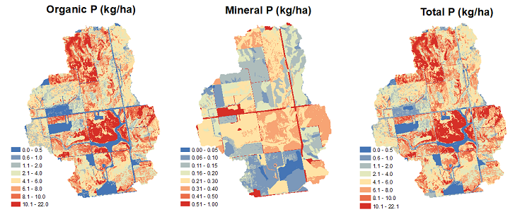
CANWET™ Spatial (HRU Scale) Distribution of Annual Average Phosphorus Forms (Organic, Mineral, Total at the “Site Level”) in a Subwatershed of the Grand River Watershed (Lake Erie Basin – Canada)
The latest “Big Data Version” of CANWET™ (developed by GREENLAND® and University of Guelph) has advanced earlier (desktop) versions by utilizing high performance parallel (cloud) computing functionality. The latest update is a fully functional web-based platform with SWAT modelling tools that can allow greater access by decision makers and stakeholders. Therefore, the new version advances the idea of evaluating cumulative effects in the watershed decision making process rather than the current practice of assessing proposed changes in isolation.
The CANWETTM evolution (since 2018) has taken advantage of high performance computing by porting existing code to a higher performing language and restructuring to operate using parallel or multi-core processing. Therefore, the platform operates now with “dramatic reductions” in simulation runtimes. The reduced runtimes also facilitated the use of new automatic calibration and verification routines for SWAT model setups – thereby, reducing project labour costs. It can also enable faster analytics for “What-If” watershed simulations and if a re-run is requested through the web-based user interface. In 2021 (and beyond), it is anticipated the CANWET™ (machine learning) web-based platform (“Powered by SWAT) will be used more by decision and policy makers in Canada and to understand better the sources of pollution (and related climate change factors). For example, this includes phosphorus which is a major contributor to Lake Erie eutrophication problems. Therefore, CANWET™ can be used to also develop sustainable policies in supporting a wide variety of watershed planning Best Management Practices and ultimately help achieve the Canadian Government’s commitments to reduce 40% phosphorus entering Lake Erie by 2025.
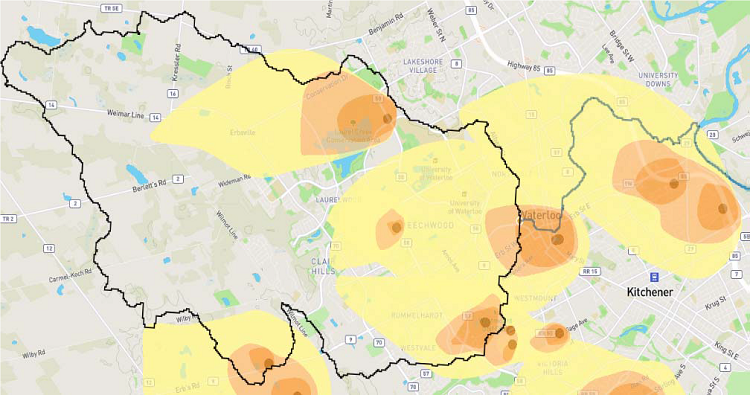
 In January 2020, another CANWET™ public – private partnership involving the City of Waterloo (Canada) was initiated by the GREENLAND® and University of Guelph team. This collaboration will develop an integrated model of surface/groundwater interactions using CANWET™ and with available “MODFLOW” databases. The platform will be used by the project team to investigate sodium chloride (salt) transport affecting the Laurel Creek Watershed. The integrated surface / groundwater platform will also take advantage of in-house high performance computing resources to calibrate and validate the CANWET™ model. This second-to-none platform will enable the Municipality to:
______________________________________________________________________________

City of Toronto
Mayor David Miller and Members of Toronto City Council extend appreciation to Greenland Group of Companies for your outstanding contribution to the City of Toronto’s Green Roof Technical Advisory Group. As a participant of the City of Toronto’s Green Roof Technical Advisory Board, you have contributed tremendously to its leadership role on climate change and helped support the development of the Toronto Green Roof By-law.
This initiative, the first of its kind in North America, sets the standard in designing sites and buildings across the city that are more environmentally friendly, a key strategy in reducing the effects of climate change.
We thank you for helping our city achieve its vision and goals on climate change – it is this kind of collaboration that makes us proud, prosperous and successful.
Best wishes for continued success.
David Miller
Mayor
City of Toronto
May 2010
City of Greater Sudbury
Re: Capreol Downtown Waterfront CIP and Whitson River Waterway Trail
The City of Greater Sudbury has used the services of Greenland International Consulting Ltd. for the design of the Capreol Downtown Waterfront and the design of the Whitson River Waterway Trail.
Greenland delivered both projects on budget and provided consistency in its leadership from the landscape team. This stability in project management meant that we were working with a company who was familiar with the City’s project and consultation processes.
The Capreol Downtown Waterfront improvements were constructed in 2018 in time for the community’s 100th anniversary and incorporated the community’s railway history into the design. Greenland was skilled at integrating the wishes of the community into cohesive and creative designs that provide great connections between the Community’s main street areas and natural features.
Melissa Riou, MCIP, RPP
Senior Planner
Community and Strategic Planning
Growth and Infrastructure Department
City of Greater Sudbury
December 23, 2020
Town of Collingwood
I would like to recognize the active involvement of the GREENLAND Ground of Companies in the Town of Collingwood's economic development efforts and dedication to helping advance the Town's vision of being a specialized technology hub. Their extensive knowledge of the water technology and land development industries, coupled with their desire to help propel Collingwood forward as a regional economic leader, are very much appreciated.
The Town is proud to have GREENLAND in the community as they have also been key supporters in facilitating introductions with renowned organizations, such as the University of Guelph, University of Waterloo, WaterTAP, Communitech, Canadian Water Resources Association and Canadian Water Network. These organizations and others will help Collingwood secure new businesses with a recreational and healthy lifestyle focus. GREENLAND is also a passionate supporter of youth networking and knowledge transfer initiatives, providing financial assistance for Collingwood Youth Centre initiatives at www.collingwoodyouthcentre.ca
Fareed Amin
Chief Administrative Officer
The Corporation of the Town of Collingwood
April 9, 2018