Latest Evolution (Year 2020 and Beyond)
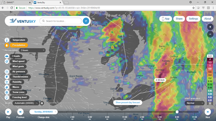
 ISWMS™ (Version ‘2’) is a fully functional web-based / open source GIS system for forecasting and visualizing flood extents in watersheds anywhere in Canada. ISWMS™ (v.2) automatically gathers Environment Canada open climate forecast databases (deterministic) and feeds them into sophisticated and computationally demanding hydrologic and hydraulic models to develop deterministic forecasts of water levels and inundation.
ISWMS™ (v.2) is deployed on a cloud (but is executed in serial-mode) and runs periodically (within hours) to develop flood forecasts for interactive web-based visualization and flood mitigation decision support. Also, given the Platform’s integration with HEC-HMS (hydrologic) and HEC-RAS (hydraulic) analytical models, ISWMS™ (v.2) has these unique attributes to:
 In January 2020, and part-of a multi-year software collaboration, GREENLAND® and University of Guelph (Canada), began the development of the next IoT Platform version of ISWMS™.
This research intends to develop a modeling extension that will allow ISWMS™ (v.2) to: 1) run efficiently on parallel compute clusters; and, 2) incorporate uncertainties associated with climate forecasts into flood extent forecasts of ISWMS™. This ISWMS™ Version ‘3’ is also referred to as “ISWMS™ - Smart”. Our team has also successfully leveraged parallel computing (via a prior project for CANWET™ and with deployment on a Cloud Analytics Platform) in developing an efficient web-based platform for calibration of hydrologic models. Our team intends to build upon this niche expertise and knowledge attained in the past software collaborations and to develop the first ISWMS™ - Smart prototype in 2020.
ISWMS™ - Smart will quantify any uncertainties in ISWMS™ (v.2) flood forecasts originating from the uncertainties inherent in the climate forecasts, by enabling ISWMS™ to run in parallel for different climate forecast scenarios. Therefore, a critical need for successful development of ISWMS™ - Smart is the development and testing of a parallel programming infrastructure for ISWMS™ to improve its efficiency. Consequently, the research pertaining to development of ISWMS™ - Smart requires continuous access to compute clusters designated for developing innovating computing solutions to complex problems. Moreover, ISWMS™ - Smart will include AI-based (machine learning) algorithms designed to optimize the use of computing resources during parallel runs of any ISWMS™ - Smart hydrologic and hydraulic models. Hence, secure (continuous) access to advanced computing resources will also be implemented to confirm the effectiveness of the new algorithms. This will also be key for future contractual partnerships too.
Spatial-temporal resolution and complexity of earth data and human-environment interactions is continuously increasing, and demanding an improvement in complexity and efficiency of flood forecasting decision support systems. ISWMS™ - Smart will significantly improve the capability (by quantifying forecast uncertainty) and efficiency (via parallelization) of ISWMS™, allow the ISWMS™ decision support system to run on large watersheds, and consequently increase the applicability of the platform for new clients. Moreover, the computational efficiency of ISWMS™ - Smart also intends to reduce operational costs (of cloud computing services). Therefore, this next evolution of ISWMS™ will also be a “disruptive market advantage” for GREENLAND®.
ISWMS™: Background (2000 - 2019)
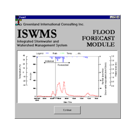
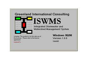 In 2000, the first Integrated Science and Watershed Management System (ISWMS™) tool was completed by GREENLAND® as a windows-based ‘SWMM and OTTHYMO’ – based decision support system for urban land stormwater management; hydrological (continuous rainfall and design storm events) modelling; and, Canadian flood forecasting capabilities.
 In 2003, GREENLAND® was retained to develop ISWMS™ (Version ‘1’) as a flood forecasting system for the 3,360km² Nottawasaga River Basin, located north of Toronto (Canada). It was then used for many years thereafter to prepare Subwatershed Management Plans in Ontario. In 2006, GREENLAND® began working on the next ISWMS™ (v.1) phases, including an open source GIS operational platform that was developed for a daily water balance, nutrient and sediment loading tool (CANWET™).
In 2010, the ISWMS™ program added new technical support partners affiliated with Canadian and U.S. universities. These independent scientists would later on assist GREENLAND® as a “science advisory team” for engineering projects that also used the company’s in-house tools.
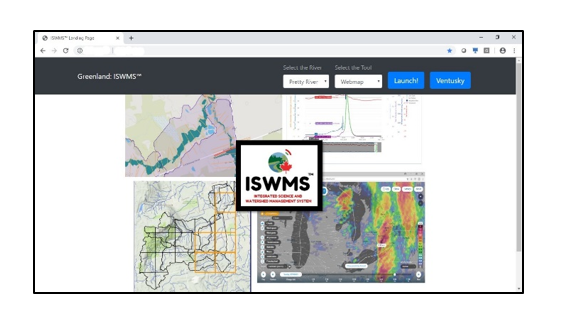 In 2016, GREENLAND® formed a strategic alliance in Europe with private and public sector teams from Sweden and France and to initiate a new IoT Platform partnership. The initial goal was to develop a cloud-based flood forecasting, flood control and floodplain mapping system (called ISWMS™ - Version ‘2’) for watershed managers and regulatory agencies. The first collaboration was completed in 2019 and where the new web-based tool is being used now in Canada to identify real-time solutions that can minimize mixed rural & urban watershed flood damages and help prevent loss of life from flood disasters. This platform was also developed for use anywhere else in the world. It includes an early warning flood forecasting system that requires powerful visualization connected to the latest (public domain) versions of HEC-HMS and HEC-RAS that are developed /maintained by the U.S. Army Corps of Engineers.
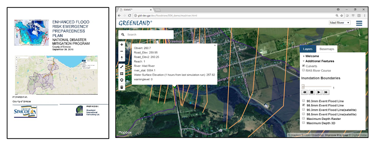
Development of the ISWMS™ Platform relied on other proprietary GREENLAND® hydrology and stormwater management modelling tools. The GREENLAND® (Canada-Europe) team consulted also with property-casualty insurers in order to develop an open/transparent system framework that could also address climate impact concerns. Other Canada-based partners included the County of Simcoe (Ontario); University of Guelph; Communitech Corporation; First Nations; and, University of Waterloo Interdisciplinary Centre on Climate Change (IC3) and Partners for Action (P4A) network. Finally, the U.S. software engineering firm ‘Civil-GEO’ was consulted on the project too. In late 2019, the GREENLAND® team (and also with the University of Guelph) secured new leverage funding to continue the ISWMS™ IoT Platform development program. In the meantime, GREENLAND® continues to use ISWMS™ (v.2) as a “free licensed asset” for its consulting client contracts (private and public sectors), and for new collaborations supported by Canada’s National Flood Damage Reduction Program, as well as future Smart Cities & Climate Change Adaptation - Protection Programs.

Lake Simcoe Region Conservation Authority
RE: Town of Innisfil (Community of Alcona) Flood Reduction Class Environmental Assessment
On behalf of the Lake Simcoe Region Conservation Authority (LSRCA), I would like to thank GREENLAND® International - Consulting Engineers for the excellent work undertaken to complete the Flood Reduction Class Environmental Assessment for the Community of Alcona. I also want to provide you our sincere appreciation for the support GREENLAND® provided both in-kind and financially which allowed the project to proceed. The approved strategy will now enable the LSRCA and Town of Innisfil to move forward with the next phase of the project so that the science-based, publicly supported solution, can be implemented to alleviate flooding impacting residents in Alcona as soon as possible.
The project goal was to develop a sustainable - engineering solution to reduce significant annual flood damages currently occurring within the Community of Alcona (Town of Innisfil) and located within the Belle Aire Creek subwatershed. The project included a Class Environmental Assessment (EA) process with extensive public and other stakeholder consultations to advance a solution involving enhancing a wetland (green infrastructure) to provide flood mitigation. The project was proposed over a decade ago and was then adopted in the Town’s Master Drainage Plan as required under the Lake Simcoe Protection Plan. It is now one step closer to completion.
The project deliverables produced by GREENLAND® included an Environmental Study Report (ESR) which now provides a science-based, well-engineered, thorough and systematic understanding of the chronic flooding that has impacted the affected settlement area in the Town of Innisfil. The Environmental Study Report (by GREENLAND®) also developed a proactive flood mitigation and resiliency plan that can now be implemented by the LSRCA, Town and other stakeholders. Finally, the project work plan satisfied requirements of Ontario's Class Environmental Assessment process and with an effective/collaborative spirit of a "public-private partnership” utilizing and ecosystem approach. The timelines to complete the project were very aggressive and I was pleased that GREENLAND® was able to complete the project on-time and budget.
In conclusion, the role that GREENLAND® played to prepare the funding application for Canada’s National Disaster Mitigation Program; securing in-kind participation of the Intact Centre on Climate Adaptation (ICCA) at the University of Waterloo; providing in-kind Intellectual Property leveraging resources, and the financial contribution helped ensure the project was a complete success. I look forward to working with your company again on other partnerships of mutual interest and would be pleased to serve as professional references on similar projects.
Michael Walters
(Former) Chief Administrative Officer
Lake Simcoe Region Conservation Authority
November 6, 2020
Cortel Group
Greenland and Dr. Goss played an important role in identifying issues with the initial study proposal.
This led to the Province and Williams Treaty First Nations reaching a resolution based on manageable terms.
With thanks,
Elsa Fancello
Project Manager
Cortel Group (Vaughan, Canada)
November 20, 2024
Town of Collingwood
I would like to recognize the active involvement of the GREENLAND Ground of Companies in the Town of Collingwood's economic development efforts and dedication to helping advance the Town's vision of being a specialized technology hub. Their extensive knowledge of the water technology and land development industries, coupled with their desire to help propel Collingwood forward as a regional economic leader, are very much appreciated.
The Town is proud to have GREENLAND in the community as they have also been key supporters in facilitating introductions with renowned organizations, such as the University of Guelph, University of Waterloo, WaterTAP, Communitech, Canadian Water Resources Association and Canadian Water Network. These organizations and others will help Collingwood secure new businesses with a recreational and healthy lifestyle focus. GREENLAND is also a passionate supporter of youth networking and knowledge transfer initiatives, providing financial assistance for Collingwood Youth Centre initiatives at www.collingwoodyouthcentre.ca
Fareed Amin
Chief Administrative Officer
The Corporation of the Town of Collingwood
April 9, 2018