GREENLAND® deliver s decision-grade watershed modeling and cumulative effects analysis through CANWET™—an advanced analytics platform supporting planning, infrastructure, and climate adaptation across urban and rural landscapes. Developed by GREENLAND® since 2003, CANWET™ combines open data workflows, GIS-enabled analysis, and high-performance computing to provide defensible, science-based insight for decision-makers responsible for watersheds, infrastructure systems, and climate resilience.
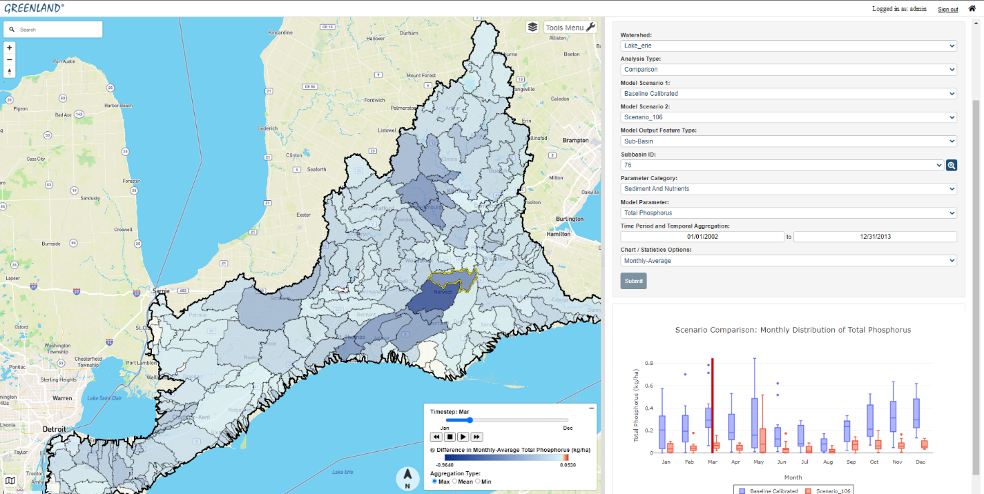
CANWET™ is "Powered by SWAT" (the Soil and Water Assessment Tool)—a widely recognized, peer-reviewed hydrologic and water quality modeling engine. The platform integrates an open-source GIS environment and decision-support analytics designed to inform watershed management; water supply and wastewater treatment infrastructure planning; urban drainage strategies (quantity and quality); and climate change adaptation. From GIS data inputs, the platform can calculate hourly water balance and related watershed parameters—including nutrients, erosion/sediment, bacteria indicators, water temperature, dissolved oxygen, and other key indicators—enabling robust scenario testing and transparent comparison of alternatives.
Decision support for planning, infrastructure, and climate adaptation
CANWET™ is used to support watershed and infrastructure decisions where stakeholders need to understand trade-offs, cumulative effects, and implementation practicality. The platform includes science-based climate change impact analytics and evaluation of mitigative Best Management Practices (BMP) and Low Impact Development (LID) strategies. CANWET™ also includes automated model calibration and verification capabilities to improve confidence in scenario results and reduce project effort—supporting more timely, iterative "what-if" analysis when decision timelines are tight.
Track record and applied use
Initial proprietary versions (mid-2000s) were completed by GREENLAND® with support from the Government of Ontario (Canada), including work associated with the award-winning Lake Simcoe Protection Plan. Subsequent updates have been applied by GREENLAND® in delivering client work across:
This practical, project-driven application has shaped CANWET™ to serve not only as a modeling engine, but as a consistent analytical foundation for comparing scenarios, supporting stakeholder engagement, and translating watershed science into decision-ready outputs.
Lake Erie nutrient reduction investigations (2015–present)
Since 2015, GRE ENLAND® and the University of Guelph (Canada) have collaborated to support watershed-wide phosphorus and other nutrient reduction investigations for the Lake Erie Basin, affecting Canadian sources draining to the lake. CANWET™ has been used to quantify and compare options and to help inform a wide range of policy and implementation pathways.
In 2018, the first Government of Canada publications reflected consideration of analytical work and findings prepared by GREENLAND® to help establish and evaluate a suite of viable options. Further confidential evaluations using CANWET™ were undertaken by GREENLAND® and later considered for the next publication update by the Government of Canada, including work in 2024.
The underlying analytical approach has examined policy and implementation options against criteria that decision-makers routinely require, including:
Additional Lake Erie work also assessed which initiatives were already in place and recommended how gaps might be filled. The objective was to determine what "best suite of policy actions" could achieve the greatest nutrient load reductions while also being effective in terms of cost, time, and social acceptance. A related analytical and stakeholder engagement approach applied CANWET™ to quantify and understand the origin and timing of nutrient loads from Canadian lands draining to Lake Erie.
AI/ML-enabled enhancements and broader accessibility
Following the pandemic, GREENLAND® initiated a longer-term collaboration with the College of Engineering at the University of Guelph to advance CANWET™ with Artificial Intelligence and machine learning features—maintaining core modeling capabilities while adding new predictive functions compatible with the SWAT analytical engine.
This collaboration has expanded the platform's accessibility and analytical reach. According to Professor Prasad Daggupati at the College of Engineering, University of Guelph: "The system can now be accessed by everyone—from government to urban planners and researchers working with the GREENLAND® team. Users can also see spatially what is happening and take appropriate actions."
Early applications of the AI-enabled functionality have supported participating agencies in efforts to reduce harmful effects associated with algal blooms and related water quality impacts within the Lake Erie Basin.
High-performance computing and web platform evolution
The latest version of CANWET™ advances earlier desktop implementations by leveraging high-performance parallel (cloud) computing. The current version includes a fully functional web-based platform with SWAT modeling tools designed to expand access for decision-makers and stakeholders, and to advance cumulative effects evaluation as a practical component of watershed decision-making—rather than assessing proposed changes only in isolation.
Since 2015, CANWET™ has taken advantage of high-performance computing by porting existing code to a higher performing language and restructuring it for parallel or multi-core processing. These enhancements have delivered dramatic reductions in simulation runtimes. Reduced runtimes also enable the use of automatic calibration and verification routines for SWAT model setups, supporting lower project labor costs and enabling faster turnarounds for scenario testing—including when stakeholders request additional re-runs through the web interface.
Looking forward: broader decision support across Canada
CANWET™—as a web-based, machine learning–enabled platform powered by SWAT—can support a broader set of decision-makers and policy leaders in Canada by improving understanding of pollution sources and climate-driven risk factors, and by enabling more efficient evaluation of watershed-scale BMP suites.
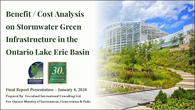
As an example, in January 2024, GREENLAND® completed a related project for the Government of Ontario using CANWET™ to deliver a Stormwater Green Infrastructure Benefit/Cost Analysis for Lake Erie Municipalities. The approach and technology were intended from the outset to be transferable to other Ontario municipalities.
As of December 2025, consultations have been underway involving GREENLAND®, the Federal Government, and Canadian Provinces regarding further use of CANWET™ (and in combination with THREATS™) to support additional public-private collaboration opportunities of mutual interest.
To discuss how CANWET™ can support your watershed planning or infrastructure decisions, contact us or request a platform demonstration.
Updated: January 7, 2026
Greenland International Consulting Ltd.
______________________________________________________________________________

Bird Construction Ltd.
Dear Team,
I wanted to extend my heartfelt thanks to each of you for your invaluable contributions to the 29 Birch Street RFP. Your dedication, insights, and collaborative spirit have been instrumental in shaping a comprehensive and compelling proposal. It’s amazing how well this team has come together and worked online, and this RFP document and team will form a repeatable and formidable approach as we see more RFPs hit the province.
On behalf of BIRD, thank you once again for your commitment and exceptional work. I look forward to our continued success together.
Sean Hart
Construction Manager
Bird Construction Ltd.
January 9, 2024
Moriyama & Teshima Architects
On behalf of Moriyama & Teshima Architects, I would like to thank you for your high level of competence and involvement expressed in the design process on the Keele Street Public School Addition and Renovation project… I felt you were integral and instrumental in coming in and taking the project from an ill-fated design…to design completion, tender and the approvals stage. You showed high levels of knowledge and understanding in your field, and your thoroughness and professionalism have led to the success of this project to date. I am thoroughly satisfied in the way you designed the services system, dealt with authorities having jurisdiction, and for your recommendations regarding budgetary concerns.
I would not hesitate in recommending you as a civil engineering consultant on any further project I am involved with.
Gene Ascenzi B.Arch, OAA, MRAIC, LEEP AP
Project Manager
Moriyama & Teshima Architects
August 25, 2014
Town of The Blue Mountains
On behalf of the Town of The Blue Mountains, we would like to thank you and your organization for your specialized technical support in a peer review capacity over the past four years… Your team not only provided timely review of all drainage related features of development applications but introduced updated municipal design criteria addressing changing climatic conditions. By unraveling the weather factors that impact snow melt potential, your team has helped the Town better understand how to be proactive in developing sustainable infrastructure.
Your team’s support assisted in keeping Town’s development projects moving forward efficiently. In addition to this, the review and introduction of updated municipal design criteria and construction standards addressing changing climatic conditions, continues to ensure the Town of The Blue Mountains fulfills its mandate for sustainable development.
Reg Russwurm MBA, P. Eng.
Director of Engineering and Public Works
Town of The Blue Mountains
February 3, 2014