
To explore how ISWMS™ supports operational flood and low-flow decision support, contact us or request a demonstration.
Updated: January 7, 2026
Greenland International Consulting Ltd.

Urbantech® Consulting
Hi Mark,
Thanks for the note. Both files went very well, both approved at LPAT and we are in detail design now. The input from the Greenland team was greatly appreciated and ensured the hydraulic analysis was accurate. Conservation Halton signed off on the hazard mapping ahead of both LPAT hearings which was huge!
J. David Leighton, C.E.T.
President
Urbantech® Consulting (Markham, Canada)
November 29, 2024
Bird Construction Ltd.
Dear Team,
I wanted to extend my heartfelt thanks to each of you for your invaluable contributions to the 29 Birch Street RFP. Your dedication, insights, and collaborative spirit have been instrumental in shaping a comprehensive and compelling proposal. It’s amazing how well this team has come together and worked online, and this RFP document and team will form a repeatable and formidable approach as we see more RFPs hit the province.
On behalf of BIRD, thank you once again for your commitment and exceptional work. I look forward to our continued success together.
Sean Hart
Construction Manager
Bird Construction Ltd.
January 9, 2024
The City of Waterloo
As a Senior Project Engineer (Water Resources) for the City of Waterloo, I would like to extend my appreciation to Greenland Consulting Engineers for providing exemplary EA planning, design, contract administration and construction inspection services for the Pond #53 Sediment Removal/Reuse and Retrofit Project.
This project was an important undertaking for the City which consisted of: the removal of 360m3 of sediment for reuse in a City owned boulevard area; removal of all additional sediment (approx. 3,000m3) from the SWMF permanent pool and forebay area to improve its operation, implementation of the retrofit design including improved maintenance access and proactive management of many unforeseen conditions throughout the duration of the project. This project also included significant logistical challenges with respect to the coordination of public access for area residents and businesses, and providing workable solutions to implementing the design as intended due to challenging unforseen site constraints.
As the Design Consultant, Contract Administrator and on-site Construction Inspector, Greenland always maintained open lines of communication between the City, Contractor and the affected residents, and promptly responded to all questions and issues raised by the Contractor, the City and the public. Greenland’s attention to detail throughout the entire duration of this assignment helped ensure the project was completed as required.
Jessica Kellerman, P. Eng
Senior Project Engineer - Water Resources
Engineering Services, Design & Construction
City of Waterloo
October 24, 2019
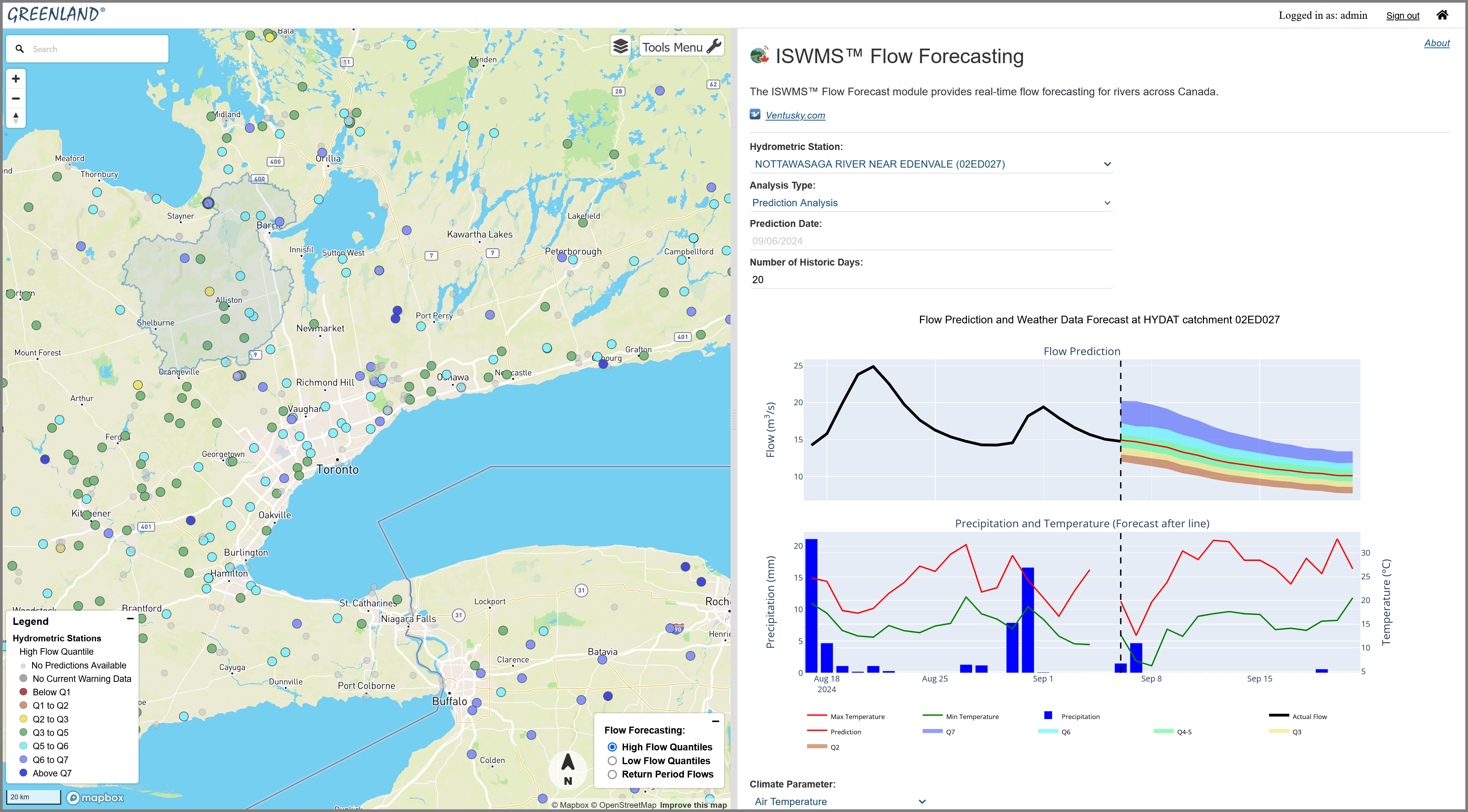
 , probabilistic flood and low-flow intelligence forecasting and mapping designed for operational decision-making at scale.