The Healthy River Ecosystem AssessmenT System (THREATS™)
Faster, defensible watershed and environmental intelligence for municipalities and utilities.
THREATS™ is a Gre enland interactive web platform—combining 100+ datasets (curated and validated where available), spatial-temporal analytics, and machine learning tools to accelerate environmental analysis and deliver decision-ready insights.
Key features include:
- Consolidate scattered land, air, and water data into one secure workspace.
- Produce clear maps, trends, and indicators for planning, compliance, and funding decisions.
- Run “what-if” scenarios (including climate context) to prioritize investments.
- Improve transparency and repeatability under public and regulatory scrutiny.
Overview
In 2015, GREENLAND® was assigned original source code rights by a team affiliated with the
Canadian Water Network to further develop THREATS™. Since then, it has evolved into an interactive Internet platform (with machine learning capabilities) for spatial-temporal analytics focusing on hydrologic, water quality (including riverine basins, inland lakes/reservoirs, and coastal/shoreline ecosystems), air quality, climate, and anthropogenic processes.
THREATS™ hosts 100+ datasets and can access third-party (validated) APIs to support dynamic updates—including data from the
Water Survey of Canada,
DataStream, Provincial/Territorial databases,
Environment and Climate Change Canada, private industry, and NGO stakeholder organizations who partner with or have retained GREENLAND®.
The combination of curated data and science-based analytics makes it fast and practical to:
- Access and visualize data from multiple sources.
- Calculate statistical indicators and spatial summaries.
- Run predictive models built into the platform (where appropriate).
- Communicate results through interactive mapping, charts, and statistics.
THREATS™ is configured for each engagement to match project scope, available data, and reporting needs—built on a mature library of data connectors and analytical workflows.
Delivery model: THREATS™ is a strategic technology that supports delivery of Greenland’s specialized consulting services (ESG, environmental, and water resources engineering). Where appropriate, we also offer managed dashboards, ongoing platform support, and licensing options for clients who want maintained views and recurring updates.
Resources
- 2025 conference presentation deck about THREATS™: Please click here.
- Recent application profile for an Ontario municipality: Please click here.
- Highlights from the AWC Source Water Protection Workshop - THREATS™ Presentation (Oct. 1, 2024): Please click here.
- How to Develop an Integrated Drinking Water Source Water Protection Plan with the THREATS® Platform: Please click here.
Core Capabilities
THREATS™ includes a growing suite of modules and datasets. Key capabilities are organized below.
Data & Analytics
- Robust, user-interactive air and water quality analyses, statistics, and forensic tools for airshed/watershed investigations.
- Water hazards, hydrometric stations, and regulated Permit to Take Water (or similar water-taking license) databases.
- Spatial analysis for calculating geometric and attribute characteristics for any region of interest within North America.
- Watershed delineation and flow path tracing tools (configurable to user-defined geographic limits).
- Travel time calculator for larger river basins within North America.
Forecasting & Scenario Tools
- Synthetic hydrographs and real-time (flood and drought) flow prediction geo-spatial analytics (up to 30-day maximum, where configured).
- Global Land Data Assimilation System–enabled, place-based climate analysis to support user-defined “What If” scenarios (climate context for planning comparisons).
- “CANWET™ Powered by SWAT” — watershed model calibration and visualization engine to assess land use change impacts and effectiveness of mitigation and source water protection scenarios.
Advanced & ML-Enabled Tools
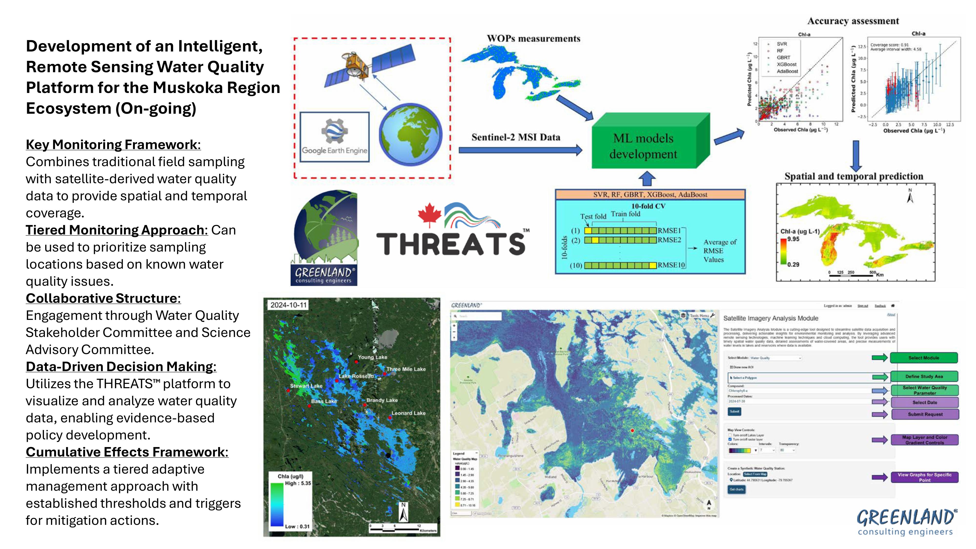
- Integration of open-source remote sensing (satellite) data covering North America with a machine learning water quality tool for real-time screening of inland lakes, drinking water reservoirs, and coastal/inland shoreline ecosystems (where appropriate; project-specific validation dependent).
- Integrated Metabase business intelligence tool that lets users ask “questions” of the database and build their own dashboards.
Specialized Applications (project- specific)
- Resource industry pipeline incident trends analysis and tools for planning new corridors affecting sensitive lands and Indigenous Peoples’ territories.
- Indigenous Peoples flow-regime and navigability Traditional Knowledge (TK) application tool to support assessment of hydropower generation and Oil Sands development impacts (e.g., Peace River and Athabasca River Delta, northern Alberta, Canada).
Additional modules and datasets are added regularly based on project needs. If a required dataset or tool is not listed, it may still be available or can be configured as part of a project.
Typical Municipal and Utility Applications
- Establish baseline watershed and water quality conditions to support capital planning and prioritization.
- Screening-level analysis for Environmental Assessments and infrastructure planning (including climate context and “what-if” scenarios).
- Identify trends, hotspots, and monitoring gaps across watersheds, lakes/reservoirs, and shoreline systems.
- Develop clear visuals and defensible summaries for internal briefings, council materials, and stakeholder engagement.
- Optional maintained dashboards for ongoing reporting and program monitoring.
How THREATS™ Supports Project Delivery
THREATS™ accelerates and strengthens consulting engineering services provided by Greenland. On a typical engagement, the platform enables:
- Interactive visualization — maps, dashboards, and charts that make complex data accessible for internal teams, council briefings, and stakeholder communication.
- Exportable outputs — figures, tables, and data formatted for technical reports, funding applications, and regulatory submissions.
- Documented methods — transparent assumptions, data sources, and limitations that support defensibility under scrutiny.
- Actionable recommendations — monitoring priorities, next-step studies, or implementation guidance based on analysis findings.
- Optional ongoing support — managed dashboards with periodic updates for clients who need continuous monitoring or reporting.
Data Governance & Client Confidence
- Validated sources: THREATS™ integrates curated datasets and connects to validated third-party APIs where appropriate.
- Client data handling: Client data can be incorporated under project-specific confidentiality requirements and client-defined access controls.
- Platform IP and deliverables: Greenland retains intellectual property in the core THREATS™ platform and reusable components. Client data remains client-owned, and project deliverables and usage terms are defined per engagement (including options for managed dashboards and licensing where appropriate).
Common Questions
#1: How does THREATS™ help reduce costs for municipalities, utilities, and resource industries while delivering measurable value?
THREATS™ consolidates large volumes of scattered North American land, air, and water data into a robust analytics environment—often reducing data assembly and processing timelines from weeks/months to hours/days. This expedites due diligence (including “what-if” and climate change impact scenarios) for infrastructure environmental assessments, coastal ecosystem programs, and riverine flood/drought analytics, and can strengthen early evidence-building for funding or grant applications.
Our AI/ML tools within THREATS™ can combine open database portals (such as DataStream) with client (firewalled) data. Satellite sensing can help fill spatial gaps between ground sampling locations and improve coverage where local validation supports use—helping clients monitor smarter, not costlier.
#2: Many municipalities struggle with limited budgets and high scrutiny. Why should they adopt innovative solutions?
The status quo is often the riskiest bet. Climate conditions are changing, budgets are constrained, and public/media scrutiny is rising. Our approach is staged: start small, prove value-for-money quickly, and scale by need—an evidence-driven path aligned with municipal risk management.
When decisions may be questioned, timely responses and clear documentation are the best defense. THREATS™ supports transparent, repeatable reporting and faster turnaround when issues arise.
What’s Coming (2026)
Watershed report cards, source water protection planning, and ensemble watershed modelling are resource-intensive procedures that require extensive data, skilled interpretation, and analysis. The current version of THREATS™ provides a modern interface for access and visualization of environmental datasets, but it assumes users have moderate-to-advanced watershed science knowledge.
AI agents can play a role in these types of reporting when coupled within the THREATS™ platform—to interpret data and create narratives aligned to appropriate guidelines, templates, and reference documents.
Our current (2026) THREATS™ development phase involves:
- Spatially aggregating a curated collection of environmental datasets and model runs.
- Providing specialized spatial context and appropriate boundaries for AI agents to interpret and report on data.
- Structuring guardrails so AI outputs remain grounded in curated datasets, approved templates, and project-specific reference materials.
The outcomes will include operationalizing results for stream health monitoring programs and enabling better community-based science engagement for proactive water quality management. The enhanced application will allow users to access, visualize, and download water quality indicators and forecasts generated by ML-enabled tools—and provide feedback and suggestions for improvement, promoting data sharing, transparency, and collaboration among researchers, managers, policy makers, and community stakeholders.
We welcome opportunities to further develop THREATS™ for specific client needs and/or with teams that have complementary intelligent technology services.
Talk to Us
For more information about THREATS™, licensing details, managed dashboards, or participating in future webinar demonstrations, please contact us.
Updated: January 7, 2026
Greenland International Consulting Ltd.